1. Research Outline
The recent high-density earthquakes that have covered the whole of Japan and the large amount of observational data from the enhanced crustal observation network are now available almost in real time. On the other hand, earthquake occurrence is a complex phenomenon with regional characteristics, and prediction is not a simple task. Therefore, the development of statistical models and realistic probability prediction are urgent issues.
In addition to numerous earthquake scenarios based on seismology, geodesy, geology, and historical records, it is necessary to develop models that fit statistical empirical laws of earthquake occurrence, to set up and maintain a catalog of records of abnormal events, and to select and acquire observation data suitable for the information sought. First, statistical models must be developed that fit various types of observation data, and these models must be used as the basis for detecting anomalous events in the data. Then, we would like to statistically identify and probabilistically express whether an anomalous event could be a precursor to a major earthquake. The concept of a probability point process is essential for modeling changes in spatio-temporal hazard and imminence to probabilistic forecasts.
The amount by which the probability of a major earthquake is increased relative to the normal probability is called the "probability gain. Even if a single extreme event alone does not produce a large enough probability gain, the probability gain of the overall forecast can be increased if several extreme events are observed simultaneously. We need to look for knowledge and anomalous events that allow us to make long-, medium-, and short-term forecasts, and use them as clues to make multi-factor probability forecasts.
We aim to effectively use seismic motion forecasting and emergency observation networks, such as the Metropolitan Area Observation Network, based on the distribution probabilities for seismological scenarios assumed from multi-element probabilistic forecasts, such as the space-time ETAS model, for the long, medium, and short term. In particular, we aim to increase the probability gain by implementing multiple forecasts online and combining them (multi-item composite probability forecasting). The output of the online probability forecasts will be used as preliminary information to improve the reliability of the earthquake early warning system, and will also be used for earthquake motion forecasting and the flexible deployment of the emergency observation network under the allocated forecast probabilities of the assumed seismological scenarios.
2. Research Objectives and Structure
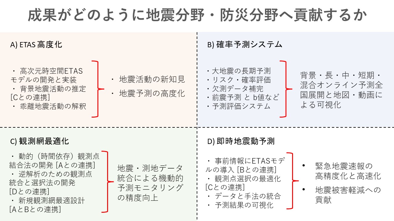
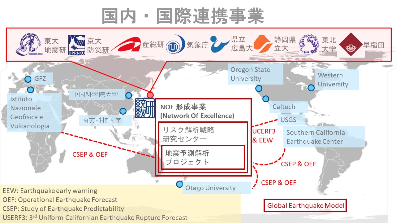
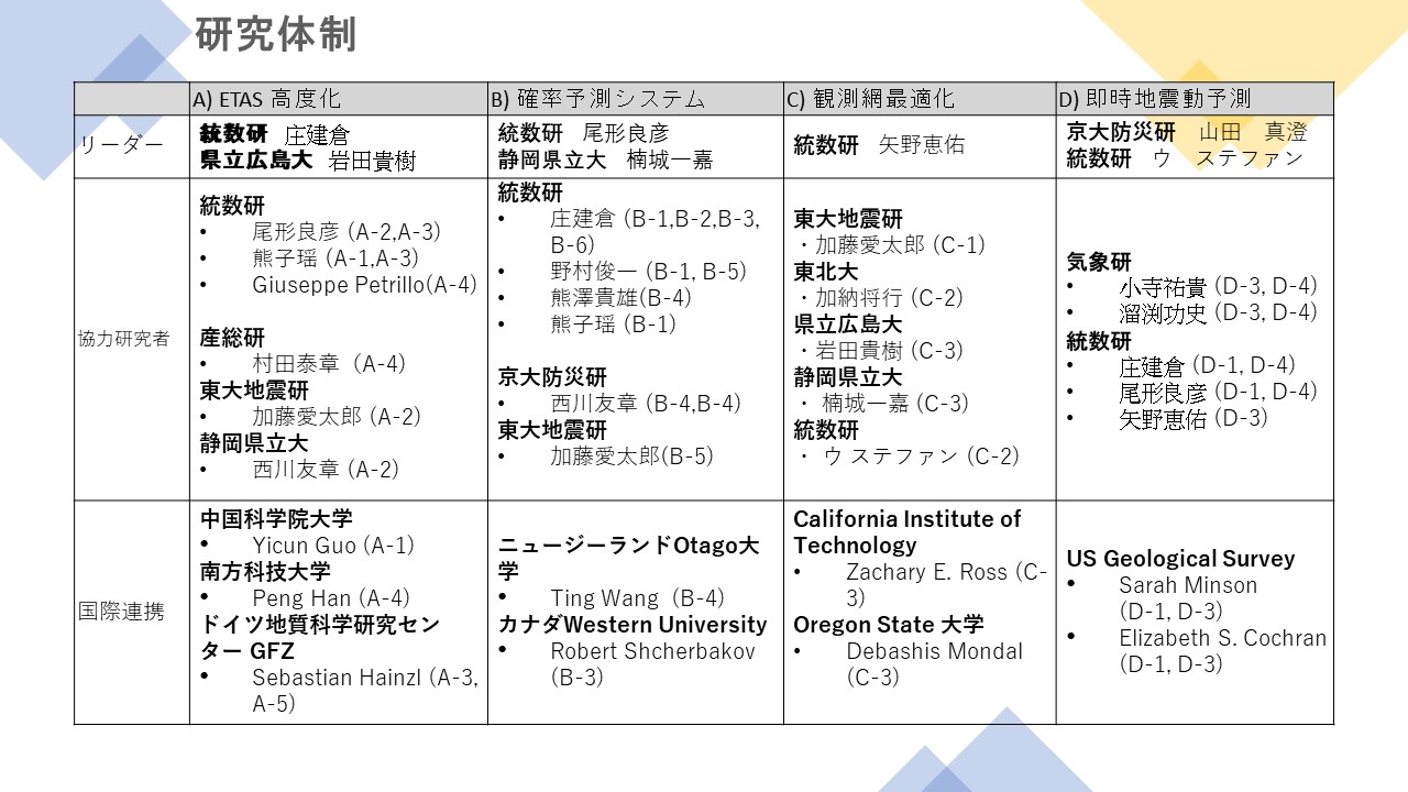
In order to realize the above goals, this project will make maximum use of the features of methods from various information and statistical science disciplines to research four themes (Figure 1): advanced modeling of seismic activity, implementation of forecasts, optimization of seismic observation networks, and immediate seismic motion forecasting. The project will be conducted in the following areas Through the promotion of each theme and mutual collaboration, we aim to contribute to the development of the earthquake field and measures for earthquake disaster prevention.
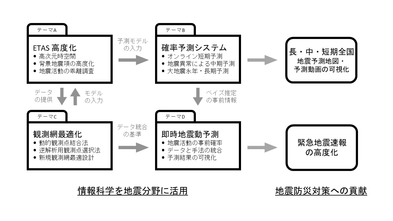
Figure 1: The four themes of this project and their mutual collaboration
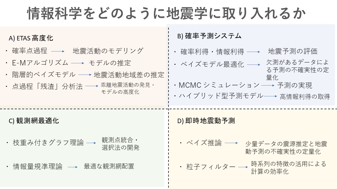
Theme A: Advancement of Epidemic Type Aftershock Sequence (ETAS) Models
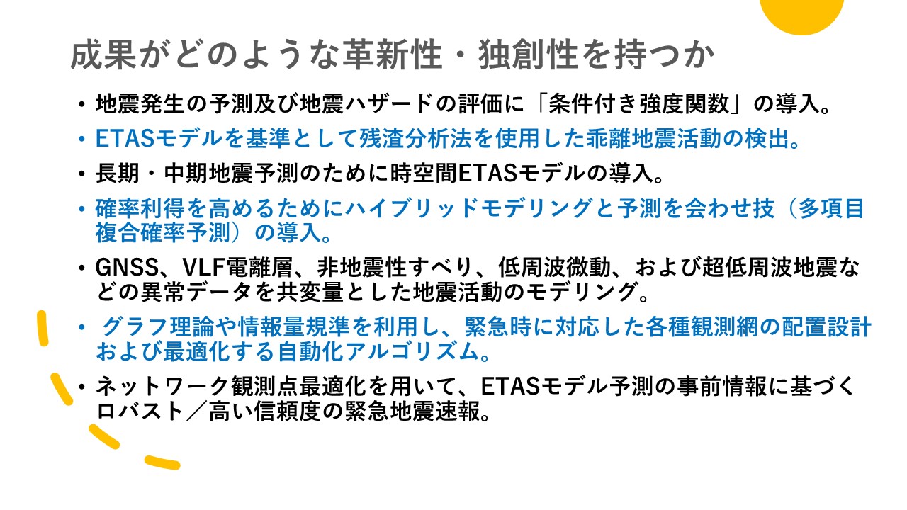
The core concept of a spatio-temporal point process model, which is necessary for a detailed spatio-temporal representation of predicted probabilities, is "conditional intensity. This corresponds to the derivative of the probability of where an event will occur under the conditions of past events and covariate data history. Starting from this conditional intensity, parameter estimation, simulation, and forecasting can be performed. In this theme, the ETAS model is ingeniously advanced to detect and quantitatively characterize causality and other factors between various earthquakes and covariates in complex systems, to evaluate the probability of future earthquakes, and to analyze the physical characteristics of seismic activity (Figure 2).
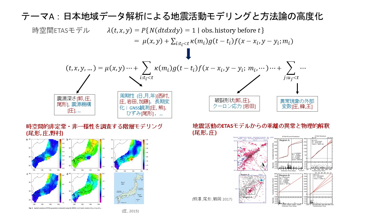
Figure 2: Extension and advancement of ETAS models
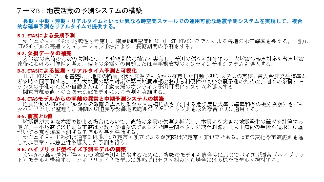
Theme B: Construction of an on-line probability forecasting system
Real-world seismic activity is subject to the anisotropy of earthquake swarms and regional statistical heterogeneity. To best fit and predict such diverse activities, an elaborate Bayesian model of spatio-temporal ETAS will be implemented for long-, medium-, and short-term prediction and online understanding of earthquake occurrence. The spatio-temporal ETAS model is then upgraded to incorporate heterogeneity in the source data, and probability forecasts for different time scales such as long, medium, and short term, and combined probability forecasts (multi-item composite probability forecasts; Figure 3) are implemented in the online system by considering crustal change and abnormal changes in seismic activity.
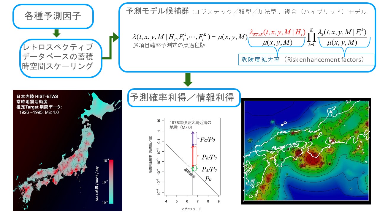
Figure 3: Construction of an online seismic activity forecasting system
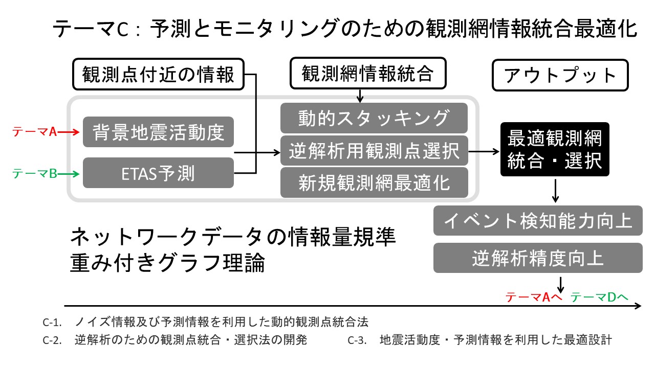
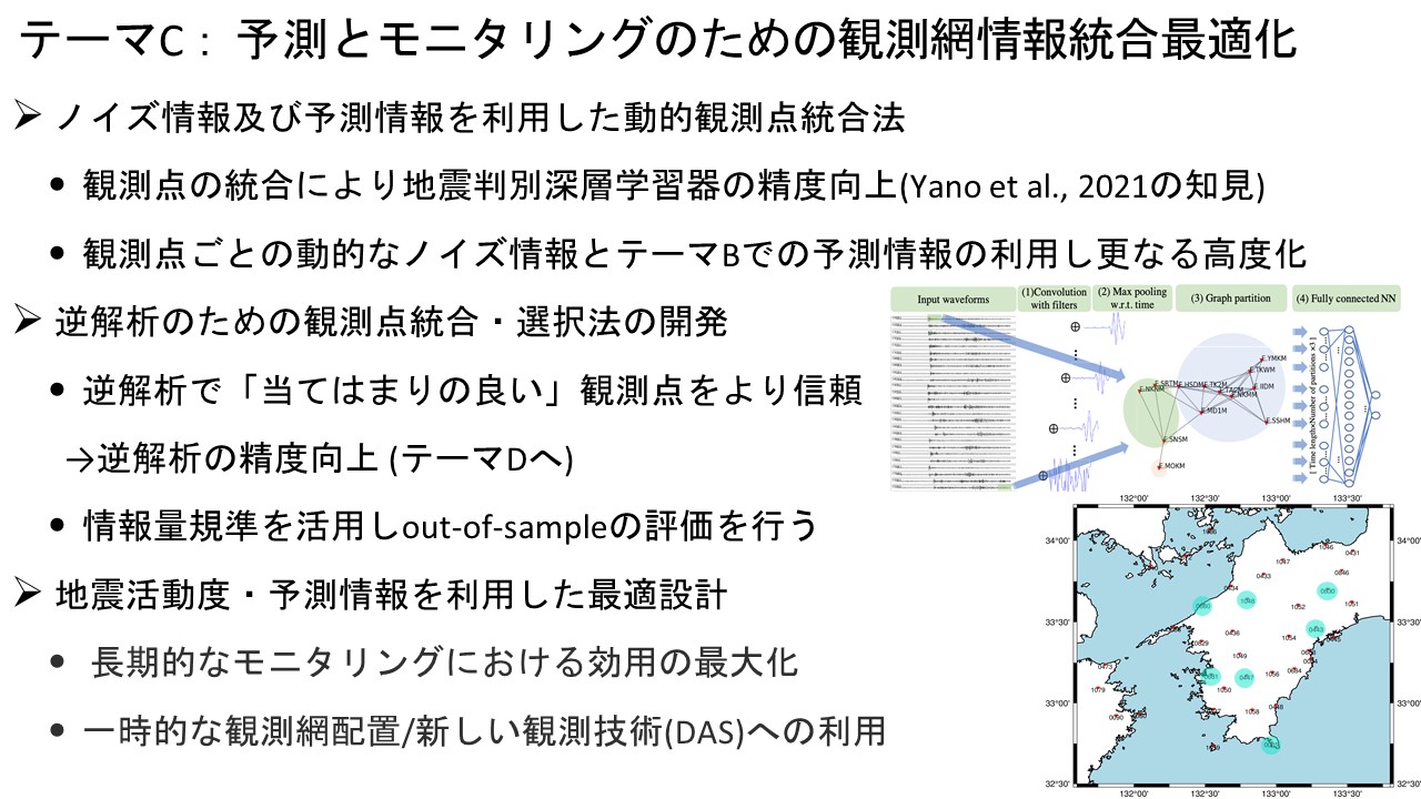
Theme C: Optimization of observation network
Japan has many seismic and geodetic observation networks, including nationwide seismic observation networks, local tight-lattice seismic observation networks, and geodetic observation networks such as GEONET. The characteristics of each observation station, such as geodetic changes between periods of seismic activity and non-seismic activity, noise, and surrounding ground conditions, vary widely, and the accuracy of analysis can be improved by appropriately selecting and integrating observation stations for analysis according to the purpose, rather than using all stations as is. We will develop an automated algorithm for selecting and integrating observation points (Figure 4) to cope with the large number and variety of observation points available today.
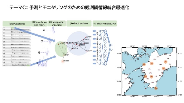
Figure 4: Selection of observation points for integration of observation points to improve the accuracy of seismic measurement and analysis
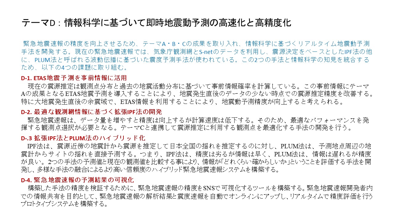
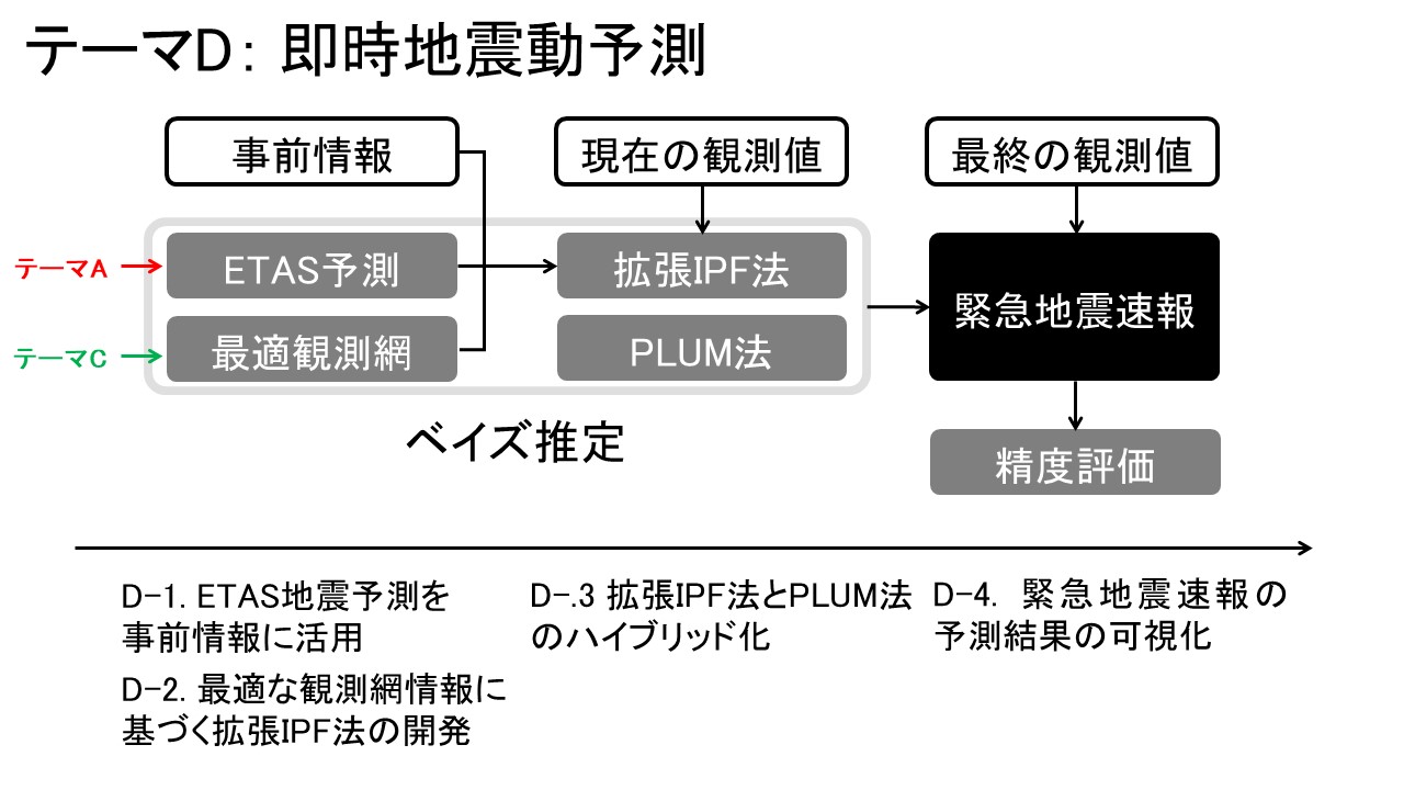
Theme D: Immediate earthquake motion prediction
In this theme, we aim to enable immediate understanding from on-line short- to medium-term probability forecasts using spatiotemporal ETAS models, etc. that consider the possibility of a series of major earthquakes, such as the Kumamoto earthquake sequence, major earthquakes around the Tohoku coast, the Nankai Trough earthquake, and the 1938 Fukushima offshore swarm earthquake, and to provide useful information including seismic motion monitoring. The objective is to develop, deploy, and implement models. We will develop an automated algorithm (Figure 5) to optimize the design of the placement of various observation networks for temporary observation after a major earthquake in terms of forecasting in advance and in a flexible manner, considering the large number and variety of observation points including temporary observation networks in response to an emergency.
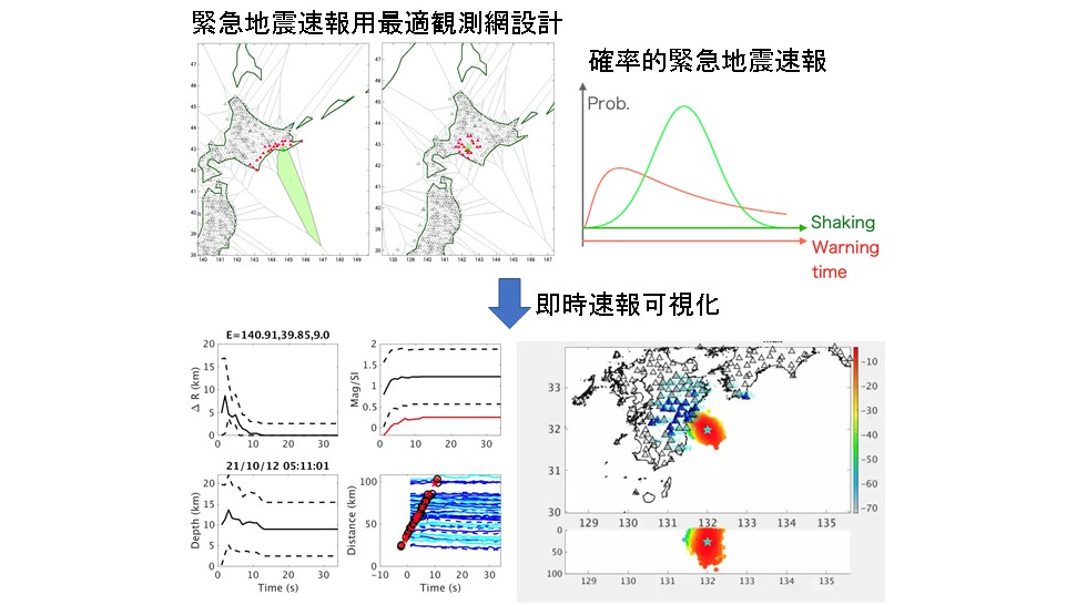
Figure 5: Optimal observation network for earthquake early warning and visualization of immediate early warning
Linkage of each theme
Based on the above distribution probabilities of seismological scenarios assumed from multi-item long-, medium-, and short-term probability forecasts, including the spatio-temporal ETAS model, we aim to effectively use earthquake motion forecasts and emergency observation networks, including mobile deployment and metropolitan area observation networks. In particular, we aim to increase the probability gain by combining forecasts (multi-item composite probability forecasting) and to implement this in online forecasts. The output of the online probability forecasts will be used in advance scenarios for earthquake early warning and as advance information to improve the unbiasedness and reliability of the system, as well as for seismic motion forecasting based on allocated forecast probabilities of assumed seismological scenarios and for the flexible deployment of emergency observation networks. We will develop means to visualize the various forecast outputs (maps, images, moving images) of the above results, and prepare for the situation where various source data can be used in real time, and we will make the best use of the features of each specialized field in cooperation with the themes of this research project and with proposals adopted by other institutions to develop the field of earthquakes and earthquake disaster prevention measures. We hope to make a contribution.